
In Wagar Fm
Type Locality and Naming
Near the village of In Wagar towards Tinkirana. The whole formation can also be observed in the section of Mont Farin Doutchi (See Stratigraphic Column in Farin Doutchi Fm entry). Group: Majias Gr
References: Greigert, 1966; Kogbe, 1973; Hanon, 1990; Dikouma, 1990, 1994; Rat et al., 1991; Dikouma et al., 1993, 1994; Zaborski & Morris, 1999; Tintant et al., 2001; Moumouni et al., 2019; Michaut, 2019a, 2019b; Laouali-Idi et al., 2021.
Synonym: Upper Sandstones and Mudstones; “Termes 3” of Greigert (1966). Im Wouagar (misspelling). Equivalent(s): Wurno Fm in the Sokoto sector of Nigeria.
Lithology and Thickness
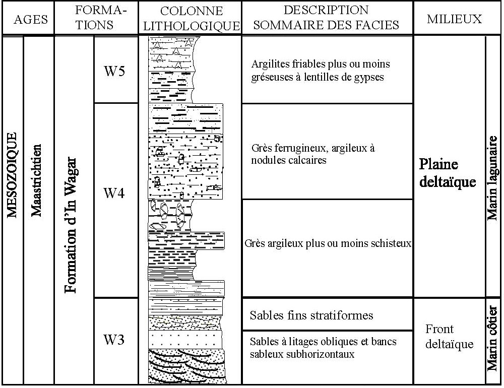
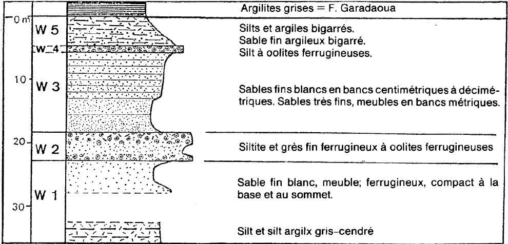
Essentially composed of detrital material: ferruginous sandstones with in-situ roots, fine sands with oblique stratification and bioturbated silts. Thickness is 60 m. It is subdivided into five units (three are shown in Fig. 1). From top to bottom, they are (Fig. 2):
- Unit W5 - from 4 to 7 m: silts and clayey silts, fine sands and fine brown, gray, khaki clay sands; gray, blue, greenish clays and argillites. Abundant centimetric phosphate nodules are associated with the debris of vertebrae. Occasional gypsum. Debris of plants; locally, presence of gastropods. Locally, at the top: a decimetric layer of beige silt with limestone cement or yellow straw limestone stained with black manganese oxides; rare beige marl lenses.
- Unit W4 - about 10 m thick, has seven levels. The base level comprises fine beige shaly sandstones, relayed vertically by argillites, then by silty argillites, topped by fine clayey sandstones more or less schistose. Fine shaly sandstones represent the intermediate level of unit W4 with calcareous concretions, which are topped by more or less ferruginous fine shaly sandstones with calcareous nodules. The top of unit W4 corresponds to medium shaly sandstones, more or less ferruginous.
- Unit W3 - is made up of four levels. Fine sandy beds represent the base level with oblique arched bedding or troughs passing vertically to massive sandy beds. Fine whitish sands represent the upper deposits of unit W3 with undulating bedding relayed at the top by bioturbated sandy beds with subhorizontal bedding. Unit W3 of the In Wagar formation has been assigned to a progradation embankment of a delta front.
- Unit W2 - Ferruginous silt or fine rust-brown ferruginous sandstone, with ferruginous oolites; spheroliths from 0.5 to 3 mm, sometimes flattened like a lens. Gastropods, plant debris. In the valley of Majya, this Member is locally absent.
- Unit W1 - from 4 to 12 m: silts and white clay silts. Beds 0.5 to 1.5 m, separated by millimetric to centimeter clayey beds, blue-gray, often ferruginous, hardened. Locally: phosphate nodules; rare plant debris. Seen at localities near Kao.
[Figure 1. Section of the In Wagar Fm at the Garadaoua village shows only the W3 to W5 Members (Source: Laouali-Idi et al., 2021).]
[Figure 2. Section of the In Wagar Fm at Mount Farin Doutchi (Source: Haron, 1990).]
Relationships and Distribution
Lower contact
Underlying unit is the Farin Doutchi Fm. The lower limit of the In Wagar Fm corresponds to the evident disappearance of the marly limestone from the top of the Farin Doutchi Fm. The contact is always marked by an alignment of decimetric concretions (20-80 cm), shaly-silty ferruginized brick-red to ocher-brown, spindle-shaped or rounded and flattened, coated with olive-green clays.
Upper contact
Overlain by the Garadaoua Fm.
Regional extent
GeoJSON
Fossils
W5 contains an abundant fauna of reptiles and fish: Dyrosauridae, Testudo, Rajidae, and selacians. The oolitic horizon W4 shows mainly plant remains, most often in the form of fragments of stalks. In Tamaské and Zangarata, the same Member presents very fossiliferous facies, with bivalves and lamellibranchs; among these fossils, generally poorly preserved, we find Turritella cf. nodosa and a lamellibranch cf. Nucula (? Nucula N cf. tenera Muller). W2 locally presents plant imprints (Mount Farin Doutchi). Corbiculid bivalves in W1.
Age
Depositional setting
A thin deltaic system prograding across the underlying marine Farin Doutchi Fm. Its advance accompanies and probably accentuates the retreat of the sea. Corbiculid bivalves in W1 suggest that it was formed by subaerial weathering, in a humid climate, of sediments deposited under freshwater conditions. Transgression T4
Additional Information